úterý 20. února 2018

The English Version

Twenty Days in The Paradise (VI)

The Fig.1: A strange light wood nearby the view of the lava cliffs rising up above the
Indian Ocean. The wood was strange to me coming from the Central Europe where this
tree species does not grow. Reunion, Cap Méchant, the southern tip of the island, taken
with my smart phone, on January 2018.
Obr.1: Podivný světlý háj opodál vyhlídky na lávové útesy, jež se zvedají nad Indickým
oceánem. Ten háj byl divný pro mne, neboť jsem ze Střední Evropy, kde tento druh stromu
neroste. Reunion, Cap Méchant, jižní cíp ostrova, pořízeno mým chytrým mobilem, leden
2018.


The Treacherous and Wild Cliffs of
The southern Coast of Reunion The Island


The Fig.2: A view of the mountainous inland from a muddy parking lot full of water pools.
Reunion, Cap Méchant, the southern tip of the island, taken with my smart phone, on
January 2018.
Obr.2: Pohled na hornaté vnitrozemí z blátivého parkoviště plného louží. Reunion, Cap
Méchant, jižní cíp ostrova, pořízeno mým chytrým mobilem, leden 2018.

A next nice example of the wild nature of some stretches of the Reunion´s coastline was its most southern tip. Venda stopped our rented Dacia Duster car in a muddy parking lot with big pools of water. As soon as I left the car I started photographing an immediate surroundings. I took some pictures of the mountainous inland and then I concentrated on the way leading to the purpose of this stop.

The Fig.3: A woody barrier with a warning panel. Reunion, Cap Méchant, the southern tip of
the island, taken with my smart phone, on January 2018.
Obr.3: Dřevěná zábrana s varovnou tabulí. Reunion, Cap Méchant, jižní cíp ostrova, pořízeno
mým chytrým mobilem, leden 2018.

I followed my attendants walking alongside a long woody fence separating the own coastline from the parking lot and a restaurant next to it. There was tall and dense vegetation behind the fence in this stretch making any view of the coastline invisible. I stopped for a moment to photograph a warning panel installed above the low woody fence. I could see there were some next buildings behind the restaurant. Maybe the low small houses had some religious sense, the Christian one. Why I thought about them so I am going to explain for a while.
The restaurant had an open garden with chairs and tables. Most of the sittings were occupied with eating and drinking people. They enjoyed the pleasant atmosphere of the place under parasols because the weather exchanged a rain for the Sun on the scene of the blue sky. Often the visitors formed families with children playing their games around their parents.

The Fig.4: A look up into crowns of the most dominant tree of the light wood nearby the lava
cliffs. Reunion, Cap Méchant, the southern tip of the island, taken with my smart phone, on
January 2018.
Obr.4: Pohled vzhůru do korun nejdominantnějšího stromu světlého háje poblíž lávových
útesů. Reunion, Cap Méchant, jižní cíp ostrova, pořízeno mým chytrým mobilem, leden
2018.
Nevertheless we resisted to the restaurant´s baits and we continued in walking further with the woody fence to our left side. A while later we stepped to a strange light wood. When I wrote that the wood was strange so it was meant from the point of the man coming from the Central Europe. Yes, this wood was unusual to me. Give a time to me and I will describe it to you in a more detailed way. But first of all let´s take a look at the greatest attraction of this place, i.e. at its wild coast.

The Fig.5: While we were walking alongside the woody barrier I took this picture of The
Indian Ocean. Reunion, Cap Méchant, the southern tip of the island, taken with my smart
phone, on January 2018.
Obr.5: Zatímco jsme kráčeli podél dřevěné zábrany, pořídil jsem tento obrázek Indického
oceán. Reunion, Cap Méchant, jižní cíp ostrova, pořízeno mým chytrým mobilem, leden
2018.
The way to the view of the attractive coast led us to an open plain at the wood´s margin to our right side. We kept going further with the woody low fence to our left side. Of course, on our way we met other people of interest to see this panorama. They formed no crowds so that the way did not resemble similar attractive places full of people in the Central Europe.

The Fig.6: A back view of the Indian Ocean and the cliffs on my way alongside the woody
barrier. Reunion, Cap Méchant, the southern tip of the island, taken with my smart phone,
on January 2018.
Obr.6: Zpětný pohled na Indický oceán a útesy cestou podél dřevěné zábrany. Reunion, Cap
Méchant, jižní cíp ostrova, pořízeno mým chytrým mobilem, leden 2018.

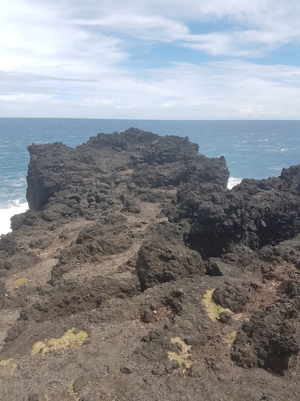
The tall and dense growth behind the woody barrier was becoming more and more sporadic and then the view of the coast opened to us in all its awful beauty. We could look at a cracked surface of lava rock cliffs rising high above the Indian Ocean in prolonging distorted fingers like tips with a lot of wider or narrower bays among them. It was as if I found myself on a prow of a gigantic ship or as if I stood up on a bizarre ambit of a fantastic mighty fort or something like this.
First we thought that to enter the cracked field of the cliffs was banned because there was the woody barrier between us and this lava rock terrain. But then we dared to bypass the obstacle in one place where its continuation was interrupted by a narrow pass. By this way we could take a careful walk a crooked back of one of the wider fingers with the better view of the dynamic contact between the cliffs and the Indian Ocean.

The Fig.7: A view of the woody barrier and the Indian Ocean from an open plain. Reunion,
Cap Méchant, the southern tip of the island, on January 2018.
Obr.7: Pohled na dřevěnou zábranu a Indický oceán z otevřené pláně. Reunion, Cap Méchant,
pořízeno mým chytrým mobilem, leden 2018.

Though we could walk the lava rock terrain behind the barrier far we could not approach to its utmost tip because the way to it would have been too much risky. Naturally, none of us wanted to finish our lives up in some of treacherous pits and breaks waiting for a fool with a foolish longing to reach the very edge of this lava rock finger. This was why we stayed within its base only but it was enough to us to see more than it would has been in a place with the barrier in front of us. This position gave us the chance to get back and side looks at the lava rocky cliffs.

The Fig.8: The picture catches the moment in which waves of the surf bumped on the lava
rock cliffs. Reunion, Cap Méchant, the southern tip of the island. Taken with my smart phone,
on January 2018.
Obr.8: Obrázek zachycuje moment, v němž vlny příboje narazily na lávové útesy. Reunion,
Cap Méchant, jižní cíp ostrova. Pořízeno mým chytrým mobilem, leden 2018.

The place did not give splendid views only. Our ears were deafened by windy attacks and the shouting surf as well. I recall as I had to hold my smart phone strongly against the windy attacks. To keep a picture on the phone´s display to be in one line was not easy, especially during an audio video recording.
Well, when all our photographing and recording seemed to be satisfied we returned to the plain behind the woody barrier and we walked it over to the light wood with its strange trees to take a rest under their sparse crowns. The tree forming a main component of the wood was noticeable with its bunch of a pile like vertical roots lifting its trunk higher above the ground. The roots were going down to the soil straightly, they were not distorted. Many trees of this species were in fruit and now you can see them on my pictures here.

The Fig.9: The lava rock cliffs on the opposite side of our view from the banned zone.
Reunion, Cap Méchant, the southern tip of the island. Taken with my smart phone, on January
2018.
Obr.9: Lávové útesy na opačné straně naší vyhlídky ze zakázané zóny. Reunion, Cap Méchant,
jižní cíp ostrova, pořízeno mým chytrým mobilem, leden 2018.

While my partners were sitting on the ground covered with a low dense growth resembling a moss a bit I used a stub as a seat. Of course I did not forget to photograph the fruits of the tree. You can see them here, too. I must admit that I did not know this species. But my additional studies and searching for the tree in various botanic sources after my return to Prague was successful. Now I know that this stranger to me is Pandanus utilis. When I saw its specimens in the wood nearby the lava rock cliffs it resembled to me something between Durio the genus and Artocarpus the genus.

The Fig.10: Venda was the first of us who stepped to the banned zone behind the woody
barrier. Reunion, Cap Méchant, the southern tip of the island, taken with my smart phone, on
January 2018.
Obr.10: Venda byl první z nás, který vešel do zakázané zóny za dřevěnou zábranou. Reunion,
Cap Méchant, jižní cíp ostrova, pořízeno mým chytrým mobilem, leden 2018.

Additionally I learnt something more about the low dense growth covering the soil under the trees in the light wood. According to my sources it was a grass named Zoysia tenuifolia in Latin.

The Fig.11: A path passing through the wood´s edge. You can see young specimens of
Pandanus utilis growing next to the path. Reunion, Cap Méchant, the southern tip of the
island, taken with my smart phone, on January 2018.
Obr.11: Pěšina procházející kol okraje háje. Vidíte mladé exempláře Pandánu Pandanus utilis
rostoucích vedle pěšiny. Reunion, Cap Méchant, jižní cíp ostrova, pořízeno mým chytrým
mobilem, leden 2018.

While we were taking a rest in the wood an older woman came to us and stopped. She covered her head with a part of her clothing preventing it from the burning sun rays but it seemed to be useless already. The pour woman was confused evidently. Standing above our sitting figures she was talking and talking very quickly something in French, maybe some biblical texts. She did not care of whether we listened to her religious litany or not. We behaved indifferently and a while later she stopped talking and left us. I could observe her clinging to a new victim not far away from the place where we were sitting. The low buildings behind the restaurant seemed to be a clue to the woman. I noticed a writing on a face of one of them. Then I thought to myself it was some Christian congregation. Unfortunately, neither I nor Venda photographed the low small houses.

The Fig.12: Globular fruits of Pandanus utilis the tree species. Reunion, Cap Méchant, the
southern tip of the island, taken with my smart phone, on January 2018.
Obr.12: Kulovité plody stromu Pandanus utilis. Reunion, Cap Méchant, jižní cíp ostrova,
pořízeno mým chytrým mobilem, leden 2018.

On our way back to the car I stopped for a short while to photograph a tuft of mushrooms. The mushrooms grew under trees of Pandanus utilis the species. Several minutes later we were getting in the car so that we could continue on in our investigative drive alongside the coastal line.

The Fig.13: Three fruits of Pandanus utilis at the closer view. Reunion, Cap Méchant, the
southern tip of the island, taken with my smart phone, on January 2018.
Obr.13: Tři plody Pandanus utilis v bližším pohledu. Reunion, Cap Méchant, jižní cíp
ostrova, pořízeno mým chytrým mobilem, leden 2018.

The Czech Version

Dvacet dní v ráji (VI)


The Fig.14: One fruit of Pandanus utilis laying in a grass among fragments of lava rock
covered with a lichen. Reunion, Cap Méchant, the southern tip of the island, taken with my
smart phone, on January 2018.
Obr.14: Jeden plod Pandanus utilis ležící v trávě mezi úlomky lávy porostlé lišejníkem.
Reunion, Cap Méchant, jižní cíp ostrova, pořízeno mým chytrým mobilem, leden 2018.

Zrádné a divoké útesy jižního
pobřeží ostrova Reunionu

The Fig.15: The tip of the lava rock "finger" was not accessible to us because the distance
between us and it was separated by many treacherous breaks and pits. Reunion, Cap
Méchant, the southern tip of the island, taken with my smart phone, on January 2018.
Obr.15: Špička lávového "prstu" pro nás nebyla přístupná, protože vzdálenost mezi
námi a jí oddělovalo mnoho zrádných trhlin a jam. Reunion, Cap Méchant, jižní
cíp ostrova, pořízeno mým chytrým mobilem, leden 2018. 

Dalším pěkným příkladem divoké povahy některých úseků reunionského pobřeží byl jeho nejjižnější cíp. Venda naše pronajaté auto zn. Dacia Duster zastavil na blátivém parkovišti s velkými loužemi vody. Jakmile jsem auto opustil, začal jsem fotit bezprostřední okolí. Pořídil jsem nějaké obrázky hornatého vnitrozemí a poté jsem se soustředil na cestu k cíli této zastávky.

The Fig.16: This photo shows trees of Pandanus utilis forming the light wood nearby the view
of the lava rock cliffs. The low bushy growth in front of the wood belongs, as I think, to the
species of Scaevola taccada and the light green carpet covering the soil of the wood is a master
piece of Zoysia tenuifolia the grass. Reunion, Cap Méchant, the southern tip of the island,
photo by V. Verner. On January 2018.
Obr.16: Tento snímek ukazuje stromy druhu Pandanus utilis tvořící světlý háj poblíž vyhlídky
na lávové útesy. Nízký keřovitý porost před lesíkem patří, jak se domnívám, druhu Scaevola
taccada
a světle zelený koberec pokrývající půdu háje je mistrovské dílo trávy Zoysia
tenuifolia
. Reunion, Cap Méchant, jižní cíp ostrova, foto V. Verner. Leden 2018.

Následoval jsem společníky kráčející podél dlouhé dřevěné ohrady oddělující vlastní pobřeží od parkoviště a restaurace vedle něj. Vysoká a hustá vegetace za ohradou v tomto úseku jakýkoliv výhled na pobřeží zneviditelňovala. Na chvilku jsem se zastavil, abych si nafotil varovnou tabuli instalovanou nad nízkou dřevěnou ohradou. Mohl jsem vidět, že za restaurací jsou nějaké další budovy. Ty nízké domky měly asi nějaký náboženský smysl, křesťanský. Proč jsem o nich tak smýšlel, vysvětlím za chvíli.
Restaurace měla otevřenou zahrádku se židlemi a stolky. Většinu z toho sezení okupovali pojídající a popíjející lidé. Užívali si příjemnou atmosféru místa pod slunečníky, protože počasí vyměnilo déšť za slunce na scéně modré oblohy. Návštěvníci často tvořili rodiny s dětmi, které si hrály své hry kol rodičů.

The Fig.17: The lava rock "finger" photographed from the opposite side.
Reunion, Cap Méchant, the southern tip of the island, photo by V. Verner.
On January 2018.
Obr.17: Lávový "prst" focený z opačné strany. Reunion, Cap Méchant, jižní
cíp ostrova, foto V. Verner. Leden 2018.

Restauračním návnadám jsme nicméně odolali a s ohradou po levé straně pokračovali jsme v chůzi dál. Po chvíli jsme vešli do podivného světlého háje. Když jsem napsal, že ten háj byl podivný, tak to bylo míněno z hlediska člověka, který pochází ze Střední Evropy. Ano, tento les byl pro mne neobvyklý. Dejte mi čas a já vám ho popíšu podrobněji. Ale nejdříve ze všeho se podívejme na největší atrakci místa, tj. na jeho divoké pobřeží.

The Fig.18: The same part of the coast as on the Fig.8 but photographed by V.
Verner. Reunion, Cap Méchant, the southern tip of the island, on January 2018.
Obr.18: Stejná část pobřeží jako na obr.8, ale focená V. Vernerem. Reunion,
Cap Méchant, jižní cíp ostrova, leden 2018.

Cesta k vyhlídce na atraktivní pobřeží nás vedla na otevřenou planinu při okraji háje po naší pravé straně. Šli jsme pořád dál s dřevěnou nízkou ohradou po levé straně. Samozřejmě jsme cestou potkávali jiné zájemce o zhlédnutí panorámatu. Netvořili žádné davy, takže cesta nepřipomínala podobná atraktivní místa plná lidí ve Střední Evropě.

The Fig.19: This picture shows the transition between the lava rock cliffs and
the open plain separated by the woody barrier. Reunion, Cap Méchant, the
southern tip of the island, on January 2018. Photo by V. Verner.
Obr.19: Tento obrázek ukazuje přechod mezi lávovými útesy a otevřenou
plání oddělený dřevěnou zábranou. Reunion, Cap Méchant, jižní cíp ostrova,
leden 2018. Foto V. Verner.

Vysoký a hustý porost za dřevěnou zábranou řídnul a pak se nám otevřel výhled na pobřeží v celé své hrůzné kráse. Mohli jsme se dívat na rozpukaný povrch lávových útesů, které se vysoko nad Indický oceán zvedaly v prodlužujících se pokřivených prstovitých cípech s mnoha širšími a užšími zátokami mezi nimi. Bylo to, jako bych se ocitl na přídi nějaké gigantické lodi nebo jako bych stanul na ochozu nějaké fantastické mocné pevnosti či tak podobně.
Zprvu jsme mysleli, že vstup na rozpraskané pole lávových útesů je zakázaný, protože mezi námi a lávovým terénem byla dřevěná zábrana. Ale pak jsme se odvážili obejít překážku v jednom místě, kde její nepřetržitost narušoval úzký průchod. Tímto způsobem jsme se mohli procházet po kostrbatém hřbetě jednoho z širších prstů s lepší vyhlídkou na dynamický kontakt mezi útesy a Indickým oceánem.

The Fig.20: A view of the mountainous inland from the parking lot caught by
V. Verner. Reunion, Cap Méchant, the southern tip of the island, on January
2018.
Obr.20: Pohled na hornaté vnitrozemí z parkoviště zachycený V. Vernerem.
Reunion, Cap Méchant, jižní cíp ostrova, leden 2018.

I když jsme se mohli procházet po lávovém terénu za zábranou, zdaleka jsme nemohli dosáhnout jeho nejzaššího cípu, protože cesta k němu by bývala až moc riskantní. Nikdo z nás nechtěl skončit život v některé ze zrádných jam a trhlin, jež čekaly na blázna s pošetilou touhou dosáhnout samotný okraj tohoto lávového prstu. Proto jsme se zdržovali pouze v rozsahu jeho základny, ale stačilo nám to k tomu, abychom viděli víc, než by tomu bývalo na místě se zábranou před námi. Tato pozice nám poskytla možnost získat zpětné a boční pohledy na lávové útesy.

The Fig.21: Pandanus utilis - the dominant tree of this light wood nearby the view of the
wild lava rock cliffs facing permanent attacks of the Indian Ocean. Reunion, Cap Méchant,
the southern tip of the island, taken with my smart phone, on January 2018.
Obr.21: Pandanus utilis - dominantní strom tohoto světlého háje opodál vyhlídky na divoké
lávové útesy čelící neustálým atakům Indického oceánu. Reunion, Cap Méchant, jižní cíp
ostrova, pořízeno mým chytrým mobilem, leden 2018.

Místo neposkytovalo jen velkolepé výhledy. Naše uši ohlušovaly větrné poryvy a také řvoucí příboj. Vzpomínám, jak jsem musel silně držet chytrý mobil proti větrným poryvům. Udržet obraz na displeji mobilu, aby byl v jedné linii, nebylo snadné, zvláště během audio video nahrávání.
Když se zdálo, že je naše focení a nahrávání uspokojeno, vrátili jsme se na planinu za dřevěnou zábranou a přešli jsme ji ke světlému háji s jeho podivnými stromy, abychom si odpočali pod jejich řídkými korunami. Strom, který tvořil nejnápadnější složku lesa, byl nápadný svazkem kůlovitých svislých kořenů, které jeho kmen zvedaly výš nad zem. Kořeny sestupovaly do půdy přímo, nebyly pokřivené. Mnoho stromů toho druhu bylo v plodu a teď je zde rovněž můžete vidět na mých obrázcích.

The Fig.22: The wood´s uniformity was interrupted by other tree species in a sporadic way
only (for example a palm as on this picture). Notice the stub in front of the palm. It consists
of several smaller ones, of the roots of Pandanus utilis. The dwelling with the conic roof can
 be seen very often in various places throughout the island. You can take a rest in it or to make
a picnic. Reunion, Cap Méchant, the southern tip of the island, taken with my smart phone,
on January 2018.
Obr.22: Uniformitu háje přerušovaly jiné stromové druhy jen sporadicky (např. palma na
tomto obrázku). Všimněte si pařezu před palmou. Sestává z několika menších, z kořenů
pandánu Pandanus utilis. Příbytek s kuželovitou střechou lze vidět na různých místech po
celém ostrově. Můžete si v něm odpočinout nebo udělat piknik. Reunion, Cap Méchant,
jižní cíp ostrova, pořízeno mým chytrým mobilem, leden 2018.

Zatímco parťáci seděli na zemi pokryté nízkým hustým porostem, který trochu připomínal mech, já použil jako sedátka pařez. Musím přiznat, že jsem ten strom neznal. Avšak dodatečné studium a pátrání po něm v různých botanických zdrojích po návratu do Prahy bylo úspěšné. Už vím, že tento cizinec pro mne je pandán Pandanus utilis. Když jsem spatřil jeho exempláře v háji opodál lávových útesů, připomínal mi něco mezi rodem durian (Durio) a rodem chlebovník (Artocarpus).

The Fig.23: As we were leaving the wood I noticed these mushrooms growing tightly next to
root branches visible on the surface of the herbaceous floor. Reunion, Cap Méchant, the
southern tip of the island, taken with my smart phone, on January 2018.
Obr.23: Když jsme háj opouštěli, všiml jsem si těchto hub rostoucích těsně vedle kořenových
větví viditelných na povrchu bylinného patra. Reunion, Cap Méchant, jižní cíp ostrova,
pořízeno mým chytrým mobilen, leden 2018.

Dodatečně jsem zjistil něco víc o tom nízkém hustém porostu pod stromy ve světlém háji. Podle mých zdrojů je to tráva pojmenovaná latinsky Zoysia tenuifolia.

The Fig.24: The mushrooms at the closer view. Reunion, Cap Méchant, the southern tip of
the island, taken with my smart phone, on January 2018.
Obr.24: Houby detailněji. Reunion, Cap Méchant, jižní cíp ostrova, pořízeno mým chytrým
mobilem, leden 2018.
Zatímco jsme v háji odpočívali, přišla k nám starší žena a zastavila se. Zakrývala si hlavu částí z oděvu a chránila ji tak před palčivými slunečními paprsky, ale zdálo se, že už je to zbytečné. Ta ubožačka byla zjevně pomatená. Stála nad našimi sedícími postavami a velice rychle cosi vykládala francouzsky, snad nějaké biblické texty. Bylo jí jedno, zda její náboženské litanii nasloucháme či ne. Chovali jsme se netečně a po chvíli v řeči ustala a opustila nás. Mohl jsem ji pozorovat, jak se lepí na novou oběť nedaleko od místa, kde jsme seděli. Zdálo se, že nízké budovy za restaurací jsou jakýmsi vodítkem k té ženě. Povšiml jsem si nápisu na průčelí jedné z nich. Tehdy jsem si pomyslel, že to je nějaká křesťanská kongregace. Bohužel, já ani Venda jsme ty nízké domky nefotili.

The Fig.25: The blue sky, the woody barrier with the entrance the lava rock "finger" at your
own risk only (to the right) as well as the light green carpet of Zoysia tenuifolia the grass on
the open plain. Reunion, Cap Méchant, the southern tip of the island, taken with my smart
phone, on January 2018.
Obr.25: Modrá obloha, dřevěné zábradlí se vstupen na lávový "prst" jen na vaše nebezpečí
(vpravo) a také světle zelený koberec trávy Zoysia tenuifolia na otevřené pláni. Reunion, Cap
Méchant, jižní cíp ostrova, pořízeno mým chytrým mobilem, leden 2018.

Cestou zpět k autu jsem se nakrátko zastavil, abych si vyfotil trs hub. Ty houby rostly pod pandány Pandanus utilis. O několik minut později jsme sedali do auta, abychom pokračovali v naší průzkumné jízdě podél pobřežní liniie.

neděle 18. února 2018

The English Version

Twenty Days in The Paradise (V)

The Fig.1: A view of The Devil´s Tip from a lower lava rock extension. You can see the
wider bay formed by the lava extension which I stood on and the Devil´s Tip. The South
West coast of Reunion the island. Nearby St. Pierre the town. Taken with my smart phone,
on January 2018.
Obr.1: Pohled na Ďáblův výběžek z nižší lávové extenze. Můžete vidět širší zátoku tvořenou
lávovou extenzí, na níž jsem stál a Ďáblovým výběžkem. JZ pobřeží Reunionu. Poblíž
městečka St. Pierre. Pořízeno mým chytrým mobilem, leden 2018.


On The Wild Coastal Stretches,
The Devil´s Tip at St. Pierre The Town

The Fig.2: The lava rock extension was not accessible to its very end because its frontal part
further in the Indian Ocean in front of your eyes was separated from its body by a wider gape
 inundated by sea water. The South West coast of Reunion the island, nearby St. Pierre the
town. Taken with my smart phone, on January 2018.
Obr.2: Lávová extenze nebyla přístupná na samý konec, protože její čelní část dále v
Indickém oceáně před vašimi zraky oddělovala od těla širší trhlina zaplavená mořskou vodou.
JZ pobřeží Reunionu, poblíž městečka St. Pierre. Pořízeno mým chytrým mobilem, leden
2018.
I introduced a common model of the Reunion´s beach to you in the previous part. But no all parts of the island´s coastline are occupied with beaches. Most of the Reunion´s coastline is formed by high steep rocky cliffs where the waves of the Indian Ocean show out their power in extra effective ways. Besides these rocky cliffs, as long as they are accessible to their very edges, give many romantic and dramatic experiences to their visitors.

The Fig.3: A cracked terrain under my feet. The holes and crevices are full of sea water. You
can see the frontal part of the lava rock extension separated by a gape from its rest which I
was standing on. The South West coast of Reunion the island, nearby St. Pierre the town,
taken with my smart phone, on January 2018.
Obr.3: Popraskaný terén pod mýma nohama. Dolíky a štěrbiny jsou plné mořské vody. Můžete
vidět přední část lávové extenze oddělené trhlinou od jejího zbytku, na němž jsem stál. JZ
pobřeží Reunionu, opodál městečka St. Pierre, pořízeno mým chytrým mobilem, leden 2018.
Because our sons (Venda and Robert) had already known some coastal stretches of this character during their first stay at the island one of our first drives led to the Devil´s Tip at St. Pierre the town.
A road is going alongside this coastal stretch and the only thing you must do is to find the right turn to it. Either you can let your car in a parking lot next to the road or you can drive up to the very edge of the cliffs. Venda chose the second possibility and he stopped the car not too far from the margin. We found ourselves on a mildly waved plain. Its surface was covered with a muddy soil changing into a bare lava rocky tips. There was neither trees nor bushes on the plateau, I could see a very sporadic vegetation cover only of which pour species diversity was reduced to a minimum of plant species on the surface of the rocky lava tips penetrating in the sea.

The Fig.4: The cracked surface of the lava rock extension in more detail. The South West
coast of Reunion the island, nearby St. Pierre the town, taken with my smart phone, on
January 2018.
Obr.4: Popraskaný povrch lávové extenze detailněji. JZ pobřeží Reunionu, poblíž městečka
St. Pierre, pořízeno mým chytrým mobilem, leden 2018.

The lava margin of the whole long plateau was wavy thus forming a system of wider or narrower bays. In the place of our view the plateau did not rise too high above the sea and there were many ways how to step down to the sea with any risk. But none of us made use of the chance.

The Fig.5: A view of the opposite side of the coast from the lava rock extension. Its starting
stretch was covered with a sporadic vegetation. From my look the coast on the opposite side
appeared to be lower with no wild cliffs. The South West coast of Reunion the island, nearby
St. Pierre the town, taken with my smart phone, on January 2018.
Obr.5: Pohled na opačnou stranu pobřeží z lávové extenze. Její počáteční úsek porůstala
sporadická vegetace. Z mého pohledu se pobřeží na opačné straně zdálo niižší bez divokých
útesů. JZ pobřeží Reunionu, opodál městečka St. Pierre, pořízeno mým chytrým mobilem,
leden 2018.

The bare surface of the marginal lava cliffs or tips was craggy and full of small or wider holes or crevices so that you had to avoid many pools because the sea surf bumping into the cliffs at regular tempo was flooding them with water sprays.

The Fig.6: It was rainy on that day, the sky was cloudy. Here you can see a depression
between the lava rock extension and the higher part of the coast where cars of visitors could
park with no limits. I noticed that some visitors stayed in their cars and they enjoyed the view
from them. The South West coast of Reunion the island, nearby St. Pierre the town, taken with
my smart phone, on January 2018.
Obr.6: Toho dne bylo deštivo, obloha byla zatažená. Zde můžete vidět pokles mezi lávovou
extenzí a vyšší částí pobřeží, kde auta návštěvníků mohla neomezeně parkovat. Všiml jsem si,
že někteří návštěvníci zůstali v autech a vyhlídku si užívali z nich. JZ pobřeží Reunionu, poblíž
městečka St. Pierre, pořízeno mým chytrým mobilem, leden 2018.

There was one lower lava tip extending further to the sea nearby our car so that me and my partners could take a walk its surface. Unfortunately you could not go up to its end ´cause its final part was interrupted by a wide gape flooded by the sea.

The Fig.7: A creeping spring of the most common coastal plant* growing in all coastal areas
 of the island. Here I photographed the plant for the second time already (see the previous part).
The South West coast of Reunion the island, nearby St. Pierre the town, taken with my smart
phone, on January 2018.
Obr.7: Plazivý výhonek nejběžnější pobřežní rostliny*, který rostl ve všech pobřežních
oblastech ostrova. Tady jsem ji fotil už podruhé (viz předešlou část). JZ pobřeží Reunionu,
opodál městečka St. Pierre, pořízeno mým chytrým mobilem, leden 2018.

Standing on this lava extension with its end further in the ocean in front of me I could see a wider bay to my left side. The bay was limited by a higher rocky cliff on the opposite side. It exceeded further in the ocean than the lava extension I was standing on. There were lower rocks in the sea water at its foot. This point was the most marked of the whole coast at my sight. I could observe the most effective impacts of the waves rightly on this dramatic steep cliff. No doubts I was looking at The Devil´s Tip at a distance. I could imagine myself the long row of ships wrecking in this evil place in the past, all the sailors struggling for their lives. How many of them could survive? How many of them became to be victims of the sharks occurring at high numbers in the local waters?

The Fig.8: Leaves of the plant on the Fig.7* at the closer view. The South West coast of
Reunion the island, nearby St. Pieere the town, taken with my smart phone, on January
2018.
Obr.8: Listy rostliny na obr.7* v bližším pohledu. JZ pobřeží Reunionu, poblíž městečka St.
Pierre, pořízeno mým chytrým mobilem, leden 2018. 

We visited to this wild coast in the end of our stay at Reunion the island once again. I will come back to it in some of finishing chapters of the serial.

The Additional remarks:
* Ipomoea pes-caprae, Convolvulaceae the family
The identification done by Adam Majer


The Czech Version

Dvacet dní v ráji (V)


The Fig.9: Our rented car parking nearby the view of the Devil´s Tip. The South West coast
of Reunion the island, nearby St. Pierre the town, taken with my smart phone, on January
2018.
Obr.9: Naše pronajaté auto parkující poblíž vyhlídky na Ďáblův výběžek. JZ pobřeží
Reunionu, poblíž městečka St. Pierre, pořízeno mým chytrým mobilem, leden 2018.


O divokých pobřežních úsecích,
Ďábelský výběžek u St. Pierre

The Fig.10: A next closer view of the cracked surface of the lava rock extension.
The South West coast of Reunion the island, nearby St. Pierre the town taken with my
smart phone, on January 2018.
Obr.10: Bližší pohled na rozpukaný povrch lávové extenze. JZ pobřeží Reunionu, opodál
městečka St. Pierre, pořízeno mým chytrým mobilem, leden 2018.

V předešlé části jsem vám představil jakýsi obecný model reunionské pláže. Avšak ne všechny části ostrovního pobřeží zabírají pláže. Většinu reunionského pobřeží formují vysoké skalnaté útesy, kde vlny Indického oceánu předvádějí svou sílu mimořádně efektivně. Navíc tyhle skalnaté útesy, pokud jsou přístupné na samé okraje, poskytují návštěvníkům mnoho romantických a dramatických zážitků.

The Fig.11: A foamy back of a wave passing by the lava rock extension at the closer view.
The South West coast of Reunion the island, nearby St. Pierre the town, taken with my
smart phone, on January 2018.
Obr.11: Zpěněný hřbet vlny míjející lávovou extenzi v bližším pohledu. JZ pobřeží Reunionu,
opodál městečka St. Pierre, pořízeno mým chytrým mobilem, leden 2018.

Protože naši synové (Venda a Robert) už poznali některé pobřežní úseky této povahy během svého prvního pobytu na ostrově, jeden z našich prvních výjezdů vedl k Ďáblovu výběžku u městečka St. Pierre.
Podél tohoto pobřežního úseku probíhá silnice a jediné, co musíte udělat je najít správnou odbočku k němu. Buď můžete nechat auto na parkovišti vedle silnice, nebo můžete zajet až k samému okraji útesů. Venda zvolil druhou možnost a zastavil auto nepříliš daleko od okraje. Nacházeli jsme se na mírně zvlněné pláni. Její povrch pokrývala blátivá půda přecházející v holé lávové výběžky. Na plošině nebyly žádné stromy ani křoviny, mohl jsem vidět jen velmi sporý vegetační kryt, jehož druhová rozmanitost se snižovala na minimum nemnoha druhů na povrchu skalnatých lávových výběžků pronikajících do moře.

The Fig.12: A wider view of the surf coming back to the bay between the lava rock extension
and the Devil´s Tip in the center of the picture´s edge to the left. The South West coast of
Reunion the island, nearby St. Pierre the town, taken with my smart phone, on January 2018.
Obr.12: Širší pohled na příboj vracející se do zátoky mezi lávovou extenzí a Ďáblovým
výběžkem ve středu okraje obrázku vlevo. JZ pobřeží Reunionu, opodál městečka St. Pierre,
pořízeno mým chytrým mobilem, leden 2018.

Lávový okraj celého táhlého plató byl zvlněný, a tak tvořil soustavu širších či užších zátok. V místě našeho výhledu se plató nezvedalo moc vysoko nad moře a na okraji útesů existovalo mnoho způsobů, jak sestoupit k moři bez rizika. Ale žádný z nás té možnosti nevyužil.

The Fig.13: A lot of pools of water in the cracked terrain of the lava rock extension at the
closer view. The South West coast of Reunion the island, nearby St. Pierre the town, taken
with my smart phone, on January 2018.
Obr.13: Spousta kaluží vody v rozpukaném terénu lávové extenze v detainějším pohledu.
JZ pobřeží Reunionu, opodál městečka St. Pierre, pořízeno mým chytrým mobilem, leden
2018.

Holý povrch okrajových lávových útesů či výběžků byl rozeklaný a plný malých nebo širších dolíků či štěrbin, takže jste se museli vyhýbat kalužím, protože příboj narážející do útesů v pravidelném rytmu je zaplavoval vodními sprškami.

The Fig.14: A dense growth of the plant on the Fig.7 and the Fig.8* at the beginning of the
lava rock extension. The South West coast of Reunion the island, nearby St. Pierre the town,
taken with my smart phone, on January 2018.
Obr.14: Hustý porost rostliny na obr.7 a 8* na začátku lávové extenze. SZ pobřeží Reunionu,
opodál městečka St. Pierre, pořízeno mým chytrým mobilem, leden 2018.

Opodál auta byl nízký lávový útes, který se protahoval dále do moře, takže jsme se mohli projít po jeho povrchu. Bohužel jsme nemohli dojít až na jeho konec, protože koncovou část přerušovala široká trhlina zaplavená mořem.

The Fig.15: The frequently visited view of the Indian Ocean and the Devil´s Tip. The South
West coast of Reunion the island, nearby St. Pirre the town, taken with my smart phone, on
January 2018.
Obr.15: Často navštěvovaná vyhlídka na Indický oceán a Ďáblův výběžek. JZ pobřeží
Reunionu, opodál městečka St. Pierre, pořízeno mým chytrým mobilem, leden 2018.

Stál jsem na tomto lávovém prodloužení s koncem dále v oceánu před sebou a po levé straně jsem mohl vidět širší zátoku. Na protější straně zátoku omezoval vyšší skalnatý útes. Přesahoval dále do oceánu než lávová extenze, na níž jsem stál. Na jeho úpatí byla v moři nižší skaliska. Tento bod byl z celého pobřeží v mém dohledu nejvýraznější. Mohl jsem pozorovat nejefektnější dopady vln právě na tento dramatický strmý útes. Bezpochyby jsem se díval na Ďáblův výběžek v dálce. Uměl jsem si představit dlouhou řadu lodí ztroskotávajících na tomto neblahém místě v minulosti, všechny ty námořníky zápolící o život. Kolik z nich dokázalo přežít? Kolik z nich se stalo obětí žraloků, kteří se ve zdejších vodách vyskytují ve velkých počtech?

The fig.16: A view of The Devil´s Tip from the higher part of the coast with parking cars. The
South West coast of Reunion, nearby St. Pierre the town, taken with my smart phone, on
January 2018.
Obr.16: Pohled na Ďáblův výběžek z vyšší části pobřeží s parkujícími auty. JZ pobřeží
Reunionu, poblíž městečka St. Pierre, pořízeno mým chytrým mobilem, leden 2018.

Navštívili jsme tohle místo na konci pobytu na Reunionu ještě jednou. Vrátím se k němu v některé ze závěrečných kapitol seriálu.

Dodatečné poznámky:
* Povijnice pomořská (Ipomoea pes-caprae), čeleď svlačcovité (Convolvulaceae)
Identifikace: Adam Majer

čtvrtek 15. února 2018


The English Version

Twenty Days in The Paradise (IV)

The Fig.1: A wandering dog in the beaches and in other places of the island
is very often. This one had an unusual collar around its neck. Maybe a sign
of The Hindu or The Buddhist influencies. Reunion, a beach nearby
St. Leu the town, taken with Nikon the camera, on January 2018.
Obr.1: Toulavý pes na plážích a jiných místech ostrova je velmi častý. Tento
měl kolem krku neobvyklý obojek. Snad známka hinduistických či
buddhistických vlivů. Reunion, pláž poblíž městečka St. Leu, pořízeno
aparátem zn. Nikon, leden 2018.


Something more on Beaches and
How I was Baptized by
The Indian Ocean

The Fig.2: The same dog as on the previous picture in a shadow of a tree.
The wandering dogs in Reunion are something like the sacred cows in India.
They wander freely about the whole island and they live with people in a
friendly coexistence. Reunion, a beach nearby St. Leu the town,
taken with Nikon the camera, on January 2018.
Obr.2: Stejný pes jako na předešlém obrázku ve stínu stromu. Toulaví psi na
Reunionu jsou něco jako posvátné krávy v Indii. Volně se toulají po celém
ostrově a žijí s lidmi v přátelské koexistenci. Reunion, pláž poblíž městečka
St. Leu, pořízeno aparátem zn. Nikon, leden 2018.

The first beach we visited to in Reunion the island was not far away from St. Leu the town where we had our base. As I could see later during visits of other beaches I can state that their character was constant so that when I describe the first one you will receive a good common picture of the average Reunion´s beach.
I must point out that my free exploration of the Reunion´s beaches did not include all beaches of the island but a part of it only, i.e. the beaches of its south west coastline. Nevertheless I suppose that a similar character can be ascribed to the other beaches of this charming tropical island, too.

The Fig.3: The beach where I was baptized by the Indian Ocean. See more in
my text. You can see the marginal barrier of the wood-park behind the sandy
zone and there is St Leu the town behind the wood-park. Reunion, a beach
nearby St. Leu the town, taken with Nikon the camera, on January 2018.
Obr.3: Pláž, kde mě Indický oceán pokřtil. Viz více v mém textu. Můžete vidět
okrajovou hradbu lesoparku za písčitou zónou a za lesoparkem je městečko St.
Leu. Reunion, pláž opodál městečka St. Leu, pořízeno aparátem zn. Nikon,
leden 2018.
My first contact with a beach begun in a parking lot. When we got out I could see no beach at my sight, no open sandy terrain in the way to the sea. I could see a shadowy wood only. The wood was in a mild slope. One tree species dominated in its composition. It was the same species as the one growing in front of our veranda. I noticed a terrain under my naked feet in Vietnamese shoes. It was sandy and covered with dead twigs and tiny cones. Trunks of many specimens of the dominant tree were standing on tangles of their roots. As if the trunks had a lot of distorted bizarre feet. Also I registered a tuft of a fungus growing at an old stub.
A while later we reached a top of the mild slope and now we could see the sea among the trunks of the wood-park as well as a stripe of the beach. We were approaching to the wood-park boundary.

The Fig.4: A warning panel informing of the risk of the shark attacks.
Reunion, a beach at St. Leu the town, taken with Nikon the camera, on
January 2018.
Obr.4: Varovná tabule informující o riziku napadení žralokem. Reunion,
pláž u St. Let, pořízeno aparátem zn. Nikon, leden 2018.
I observed no crowds of people on that day. The own beach was almost empty and then I could enjoy the beauty of the free open room formed by the ocean, the sky and the sandy band only.
Of course, the wood-park, now behind us, was not continuous, in places it was interrupted by an open places and here and there we could see a stand or a restaurant. But first buildings I saw as we were passing through the wood-park were two low a tower like things and I thought them to be observatories of beach watchers. Nearby the low towers we encountered upon a warning panel informing us in French of the risk of the sharks. This warning was a part of every beach I could have the chance to visit to in Reunion. Unfortunately or fortunately I never glanced the famous triangular back fin cutting through the ocean´s surface.

The Fig.5: Well, according to more warning panels this beach seemed to be
quite a dangerous place to take a bathing! Reunion, a beach at St. Leu the town,
taken with Nikon the camera, on January 2018.
Obr.5: Podle více varovných tabulí se zdálo, že tato pláž je dost nebezpečné
místo na koupání! Reunion, pláž u městečka St. Leu, pořízeno aparátem zn.
Nikon, leden 2018.
Last trees growing in the sand of the very beach band were palms in sporadic numbers. As if they wanted to take a bathe in the Indian Ocean. As if they wanted to put an accent to their slim and elegant silhouettes in the empty airy room. Often cartoonists draw a remote island with a few of palms growing in its coast. Now I have already known that this has been no exaggeration. That´s true: The palms have formed a frontal line in the sand at the sea.

The Fig.6: Two low observatories for beach watchers in the areal of the wood-park. Reunion,
one beach nearby St. Leu the town. Taken with my smart phone, on January 2018.
Obr.6: Dvě nízké pozorovatelny pro hlídače pláže v areálu lesoparku. Reunion, jedna pláž
opodál městečka St. Leu. Pořízeno mým chytrým mobilem, leden 2018.

A ridiculous story happened to me just on this beach. With my trousers tucked up to my knees for the first time I decided to step into a shallow surf of the Indian Ocean. My purpose was simple. I wanted to record the structure of the waving surf as close as possible with my smart phone. But as soon as my naked feet in Vietnamese shoes entered the shallow water and I did two or three steps forward the surf started coming back to me. I underestimated its return and its power! My previous experience with wading in a surface with no troubles was from a Sicily coast nearby Catania the city but it was The Mediterranean Sea! In one moment I was standing with the sea water above my ankles holding my smart phone in one hand and recording the surf in front of me. In the second moment the situation changed rapidly. Suddenly I was standing in the sea water flooding rims of my tucked trousers up. I tried to do one step or two with my back to the coast without turning the phone video-recording off but I lost the right Vietnamese shoe just in the moment as the surf took a back motion taking with it my loosen shoe. I made a poor try to catch the shoe but it was out of my reach already. I forgot to turn my phone off totally. It did not ceased recording the scene in which I was becoming the funniest element. In the moment when I felt the sandy bed under my feet to be started moving like an escalator in a supermarket I tried to turn myself to the coast and to leave the mighty element. But my balance system was so confused already that I lost my balance and fell in the sea water in all my length together with the smart phone. A moment later I was on my feet again and wet to the skin I managed to stumble to the sandy land at last. I think my partners were watching my theater with a great amusement. This was the way how I was baptized by the Indian Ocean.
Karel saved my Vietnamese shoe as it was returning on a next back wave. My smart phone survived my baptism well but it refused to charge its battery for several hours till its contact with a cable was quite dry. But it did not loss its function. In that evening I could replayed the recording to the rest of our crew in our veranda. The recording has been ended up with a reverse picture as if I took it from a looping air plain immediately before its crash. I have had this memorial video-recording in my black box till now and it has been stored in the memory of my main computer as well.

The Fig.7: In places the palms were the only trees occupying the sandy zone between the sea
and the wood-park barrier in sporadic numbers. Reunion, one beach nearby St. Leu the town,
taken with my smart phone, on January 2018.
Obr.7: Místy byly palmy jedinými stromy, které zabíraly písečnou zónu mezi mořem a hradbou
lesoparku ve sporadických počtech. Reunion, jedna pláž poblíž mestečka St. Leu, pořízeno
mým chytrým mobilem, leden 2018. 

We were in the beach of my baptism second time in total. The second visit showed us the beach to be much more crowded than it was for the first time but, strangely, no swimmers were in the sea. Karel, far a greatest lover of bathing of us, put his clothes off and with no hesitation he entered the sea. Robert gave our GoPro camera to him to take some audio video recordings in the sea. But Karel enjoyed the sea water for a short while only because suddenly a sharp whistle was audible from somewhere in the beach. The signal was given by a beach watcher and Karel had to leave his beloved medium. It was not much sure of why exactly bathing was banned in that time but nobody explained it to us. Maybe a shark was seen swimming nearby the beach or it was some other reason. None of us could speak in French so it was useless to try to learn something more. Nevertheless we got a not too long recording from Karel´s short stay in the sea water due to the GoPro camera. It has included the sharp whistle finishing the Karel´s bathing up as well.

The Fig.8: I took this more detailed look at the oceanic surf´s structure a while before my
fall into the sea water (read more about it in my text). Reunion, in one beach nearby St. Leu
  the town, taken with my smart phone, on January 2018.
Obr.8: Tento detainější pohled na strukturu oceánského příboje jsem pořídil chvíli před svým
pádem do vody (čtěte o tom víc v mém textu). Reunion, na jedné pláži poblíž městečka St.
Leu, pořízeno mým chytrým mobilem, leden 2018.

My purpose was not to take a bathe and then while Karel was in the sea I was wandering about the beach and from time to time I was photographing something what was interesting or attracting to me. I noticed both smaller and bigger fragments of dead remnants of some sea corals or dead rests of the sea urchins lying on the sand. These items seemed to be the most abundant at the rim of the ocean. I tried to search for any else rests of the sea life such as a starfish was but my efforts were unsuccessful. The Indian Ocean around all the island seemed to be very abundant at long coral barriers off the shore. We could observe as the sea waves were rising at a distance as if the sea water bumped to some invisible obstacles from the perfect view from our veranda many times and this phenomena could be observed in many other parts of the coastline we had the chance to see. An indirect prove of it may be that the Reunion´s beaches were not covered with fine sand only because it contended a lot of coarse and hard fragments of sea corals including other tiny things with very sharp edges, of both inorganic and organic origins. Of course, this fragments made a way to the sea more difficult. We had to choose our way with a great carefulness otherwise we exposed your naked feet to an injury. I could observe children in various beaches and I had to admire their skill to avoid all sharp things laying on their ways between the sea and the dry land quickly and easy. In comparison with them at the beginning I walked this terrain slowly and in a very clumsy way but gradually I became to be more familiar with it. But various dangers threatened your naked feet not only in dry stretches of the beaches. The sea bed could be treacherous in a similar way, too.

The Fig.9: This pidgeon like bird has often been seen in the tighter contacts
with people in the island. I photographed it searching for something to eat
nearby us at the edge of the wood-park. Reunion, one beach nearby St. Leu
the town, taken with Nikon the camera, on January 2018.
Obr.9: Tento holubovitý pták byl na ostrově často viděn v těsnějším kontaktu s
lidmi. Fotil jsem ho při pátrání po něčem k snědku nedaleko od nás na okraji
lesoparku. Reunion, jedna pláž opodál městečka St. Leu, pořízeno aparátem zn.
Nikon, leden 2018.

The Fig.10: The same bird species as on the Fig.9. A view from the back side.
Reunion, one beach nearby St. Leu the town, taken with Nikon the camera,
on January 2018.
Obr.10: Tentýž ptačí druh jako na obr.9. Pohled ze zadní strany. Reunion, jedna
pláž opodál městečka St. Leu, pořízeno aparátem zn. Nikon, leden 2018.
Well, here I finish this part but the theme of the Reunion´s beaches has not been far exhausted yet. This is why I am going to come back to it in some of next parts of my serial.

The additional remarks:
* Ipomoea pes-caprae, Convolvulacea the family
The plant was identified by Adam Majer
** Vimex trifolia, Lamiaceae
The plant identified by A. Majer


The Czech Version

Dvacet dní v ráji (IV)


The Fig.11: I made to take only one portrait of this beautiful crab. By chance
I noticed it as it was removing from one hiding-place under stones to another.
To see its side motion forward was fascinating to me. It was very fast. Reunion,
in one beach nearby St. Leu the town, taken with Nikon the camera,
on January 2018.
Obr.11: Stihnul jsem pořídit pouze jediný portrét tohoto krásného kraba.
Náhodou jsem si ho povšiml, jak se přemísťuje z jedné skrýše pod kameny
do druhé. Pozorovat jeho boční pohyb vpřed mě fascinovalo. Byl velmi rychlý.
Reunion, na jedné pláži poblíž městečka St. Leu, pořízeno aparátem zn. Nikon,
leden 2018. 


Něco víc o plážích a
Jak jsem byl pokřtěn
Indickým oceánem

The Fig.12: A fragment of a sea coral brought by the ocean to the sandy coast.
Reunion, one beach nearby St. Leu the town, taken with Nikon the camera,
on January 2018.
Obr.12: Úlomek mořského korálu přinesený oceánem na písčité pobřeží.
Reunion, jedna pláž poblíž městečka St. Leu, pořízeno aparátem zn. Nikon,
leden 2018.

The Fig.13: A next example of other sea coral´s piece on the sandy coast.
Reunion, one beach at St Leu the town, taken with Nikon the camera, on
January 2018.
Obr.13: Další příklad jiného kousku mořského korálu na písečném pobřeží.
Reunion, jedna pláž u městečka St. Leu, pořízeno aparátem zn. Nikom. leden
2018.
První pláž, kterou jsme na Reunionu navštívili, nebyla daleko od městečka St. Leu, kde jsme měli základnu. Jak jsem mohl vidět později, během návštěv jiných pláží, mohu kostatovat, že jejich charakter byl konstantní, takže když tu první popíšu, získáte dobrý obecný obraz průměrné reunionské pláže.
Musím podotknout, že můj volný průzkum reunionských pláží nezahrnoval všechny pláže ostrova, ale pouze část z něj, tj. pláže jeho jihozápadního pobřeží. Nicméně, předpokládám, že podobný charakter může být připsán také ostatním plážím tohoto okouzlujícího ostrova.

The Fig.14: A view of the distorted roots bearing this tree species trunks above
the sandy terrain of the wood-park. Reunion, in one beach at St. Leu the town,
taken with Nikon the camera, on January 2018.
Obr.14: Pohled na pokřivené kořeny nesoucí kmeny tohoto druhu stromu nad
písčitým terénem lesoparku. Reunion, na jedné pláži u městečka St. Leu,
pořízeno aparátem zn. Nikon, leden 2018.

Můj první kontakt s pláží začal na parkovišti. Když jsme vystoupili, žádnou pláž v dohledu jsem neviděl, žádný otevřený písčitý terén ve směru k moři. Viděl jsem jen stinný háj. Les byl v mírném svahu. V jeho skladbě převládal jeden druh. Byl to stejný druh jako ten, co rostl před naší verandou. Všímal jsem si terénu pod bosýma nohama ve vietnamkách. Byl písčitý a pokrytý větévkami a drobounkými šištičkami. Kmeny mnoha exemplářů toho převládajícího stromu stály na spletích kořenů. Jako by ty kmeny měly spousty pokřivených bizarních nohou. Zaznamenal jsem také trs nějaké houby rostoucí u starého pařezu.
O chvíli později jsme dosáhli vrcholu mírného svahu a teď už jsme mezi kmeny leso-parku mohli vidět moře a také pruh pláže. Blížili jsme se k hranici leso-parku.

The Fig.15: A very often plant* creeping in the coastlines, on a sandy surface
nearby the sea. Here I could see it in flower but the flowers never were open.
As soon as I learn more about it I will add its scientific name to this post.
Reunion, one beach at St. Leu the town, taken with Nikon the camera, on
January 2018.
Obr.15: Velmi častá rostlina*, která se plazí na pobřežích, na písčitém terénu
opodál moře. Tady jsem ji mohl vidět v květu, ale květy nikdy nebyly otevřené.
Jakmile o ní zjistím víc, dodám do tohoto postu její vědecký název. Reunion,
jedna pláž u městečka St. Leu, pořízeno aparátem zn. Nikon, leden 2018.

The Fig.16: A part of a creeping stem with flowers and leaves at the closer
view. The same specimen* as on the Fig.15. Reunion, a beach at St. Leu the
town, taken with Nikon the camera, on January 2018.
Obr.16: Část plazivé lodyhy s květy a listy detailněji. Tentýž exemplář* jako
na obr.15. Reunion, pláž u městečka St. Leu, pořízeno aparátem zn. Nikon,
leden 2018.

Toho dne jsem žádné davy lidí nepozoroval. Vlastní pláž byla skoro prázdná, a tudíž jsem se mohl těšit z krásy toho volného otevřeného prostoru tvořeného jen oceánem, oblohou a písečným pásem.
Ovšem, že lesopark, nyní za námi, nebyl nepřetržitý, místy ho přerušovala otevřená místa a tu a tam jsme viděli stánek nebo restauraci. Avšak první stavby, které jsem uviděl, jak jsme procházeli lesoparkem, byly dvě nízké věžovité věci a já je považuju za pozorovatelny strážců pláže. Opodál nízkých věží jsme narazili na varovnou tabuli, která nás ve francouzštině informovala o riziku žraloků. Tohle upozornění bylo součástí každé pláže, kterou jsem měl možnost na Reunionu navštívit. Bohužel či naštěstí, nikdy jsem proslulou trojúhlou hřbetní ploutev prořezávající se hladinou oceánu nezahlédl.

The Fig.17: A small flock of a sparrow like bird species on steps of a low
ruin standing at the edge of the wood-park. This was the most abundant
species in the island. Reunion, a beach at St. Leu the town, taken with Nikon
the camera, on January 2018.
Obr.17: Maké hejno vrabci podobnému druhu na schodech nízké ruiny stojící
na okraji lesoparku. Tohle byl nejhojnější druh na ostrově. Reunion, pláž u
městečka St. Leu, pořízeno aparátem zn. Nikon, leden 2018.
The Fig.18: One specimen of the same bird species as on the Fig.17 at the
closer view. Reunion, a beach at St. Leu the town, taken with Nikon the
camera, on January 2018.
Obr.18: Jeden exemplář stejného ptačího druhu jako na obr.17 detailněji.
Reunion, pláž u městečka St. Leu, pořízeno aparátem zn. Nikon, leden 2018.

Poslední stromy rostoucí v písku samotného plážového pásma byly palmy v malých počtech. Jako by se chtěly vykoupat v Indickém oceáně. Jako by chtěly zdůraznit své štíhlé a elegantní siluety v tom prázdném vzdušném prostoru. Karikaturisté často kreslí odlehlý ostrov s pár palmami rostoucími na jeho pobřeží. Teď už vím, že tohle žádnou nadsázkou není. Je to pravda: Palmy tvoří v písku u moře přední linii.

The Fig.19: Also I encountered on this flowering bush** in the wood-park. This is a whole
look at it. Reunion, a beach at St. Leu the town, taken with my smart phone, on January
2018.
Obr.19: Také jsem v lesoparku narazil na tento kvetoucí keř**. Toto je celkový pohled na něj.
Reunion, pláž u městečka St. Leu, pořízeno mým chytrým mobilem, leden 2018.

The Fig.20: A view of one flower spike of the bush (on the Fig.19)** in the more detail.
The flowers seem to resemble Lamiaceae the family. Reunion, a beach at St. Leu the town,
taken with my smart phone, on January 2018.
Obr.20: Pohled na jedno květenství keře (na obr.19)** detailněji. Zdá se, že květy připomínají
čeleď hluchavkovitých (Lamiaceae). Reunion, pláž u městečka St. Leu, pořízeno mým
chytrým mobilem, leden 2018.

Právě na téhle pláži se mi stala směšná historka. S kalhotami vykasanými ke kolenům jsem se poprvé rozhodl vejít do mělkého příboje Indického oceánu. Můj záměr byl prostý. Chtěl jsem si natočit strukturu vlnícího se příboje, co nejblíže chytrým mobilem. Ale jakmile mé bosé nohy ve vietnamkách vstoupily do mělké vody a udělal jsem pár kroků kupředu, příboj se začal vracet ke mně. Jeho návrat a sílu jsem podcenil! Předešlou zkušenost s broděním v příboji jsem měl ze sicilského pobřeží opodál města Catanie, ale to bylo Středozemní moře! V jedné chvíli jsem stál v mořské vodě nad kotníky, držel jsem v ruce chytrý mobil a nahrával si příboj před sebou. Ve druhé chvíli se situace rapidně změnila. Pojednou jsem stál v mořské vodě, která mi zaplavovala okraje vykasaných kalhot. Pokusil jsem se udělat pár kroků zády k pobřeží, aniž bych vypnul videonahrávání mobilu, ale ztratil jsem pravou vietnamku právě v momentě, když příboj vzal zpětný pohyb, berouce uvolněnou vietnamku s sebou. Chabě jsem se pokusil vietnamku zachytit, ale už byla mimo můj dosah. Mobil jsem úplně zapomněl vypnout. Neustával nahrávat scénku, v níž jsem se stal nejlegračnějším prvkem. V okamžiku, kdy jsem měl pocit, že písčité dno pod nohama mi začíná ujíždět jako ekalátor v supermarketu, pokusil jsem se otočit k pobřeží a opustit ten mocný živel. Avšak můj rovnovážný systém byl už tak zmatený, že jsem pozbyl rovnováhy a poroučel jsem se do mořské vody spolu s mobilem v celé své délce. Ihned jsem byl zase na nohou a promočený na kost zvládl jsem konečně doklopýtat na písčitou souši. Myslím, že parťáci sledovali mé divadlo s velkým pobavením. Takhle mě Indický oceán pokřtil.
Karel zachránil mou vietnamku, jak se vracela na další zpětné vlně. Chytrý mobil přežil můj křest dobře, ale po několik hodin odmítal dobít baterii, dokud jeho kontakt s kabelem nebyl zcela suchý. Ale funkčnost neztratil. Toho večera jsem mohl nahrávku přehrát zbytku naší posádky na verandě. Nahrávka je zakončena obráceným obrazem jako bych ji pořídil z lopingujícího letadla bezprostředně před havárií. Mám tuhle památnou videonahrávku ve své černé skříňce dodnes a je rovněž uložena v paměti mého hlavního kompu.

The Fig.21: A next very abundant tree or a bush growing at the island´s
beaches or coasts. This is a young specimen. Reunion, a beach at St. Leu the
town, taken with Nikon the camera, on January 2018.
Obr.21: Další velmi hojný strom či keř u pláží nebo pobřeží ostrova. Tohle je
mladý exemplář. Reunion, pláž u městečka St. Leu, pořízeno aparátem zn.
Nikon, leden 2018.

The Fig.22: A taller and older specimen of the tree on the Fig.21. Reunion, a beach at St. Leu
the town, taken with Nikon the camera, on January 2018.
Obr.22: Vyšší a starší exemplář stromu na obr.21. Reunion, pláž u městečka St. Leu, pořízeno
aparátem zn. Nikon, leden 2018.

Na pláži mého křtu jsme byli celkem dvakrát. Druhá návštěva nám pláž ukázala mnohem lidnatější než tomu bylo poprvé, ale divné bylo, že v moři nebyli žádní plavci. Karel, daleko největší milovník koupání z nás, se svlékl a bez váhání vstoupil do moře. Robert mu dal GoPro kameru, aby v moři pořídil nějaké záznamy. Ale Karel si užíval mořské vody jenom krátkou chvíli, protože pojednou byl slyšitelný odkudsi z pláže ostrý hvizd. Ten signál vydal strážce pláže a Karel musel své milované médium opustit. Nebylo moc jisté, proč bylo v tom čase koupání zakázáno, ale nikdo nám to nevysvětlil. Snad poblíž pláže plaval žralok, nebo to byl nějaký jiný důvod. Nikdo z nás francouzky neuměl, takže bylo zbytečné pokoušet se dozvědět něco víc. Přesto jsme získali díky kamerce GoPro nepříliš dlouhou nahrávku z Karlova krátkého pobytu v mořské vodě. Zahrnuje rovněž ostrý hvizd zakončující Karlovo koupání.


The Fig.23: There were only two men in kayaks in the ocean on that day.
Reunion, a beach at St. Leu the town, taken with Nikon the camera, on
January 2018.
Obr.23: Toho dne byli v oceánu pouze dva muži v kajacích. Reunion, pláž
u městečka St. Leu, pořízeno aparátem zn. Nikon, leden 2018.

Mým záměrem nebylo vykoupat se, a tudíž, zatímco Karel byl v moři, já se toulal po pláži a občas jsem vyfotil něco, co mě zajímalo nebo přitahovalo. Všímal jsem si meších a větších mrtvých ostatků některých mořských korálů nebo mrtvých zbytků mořských ježků ležících na písku. Zdálo se, že tyto položky jsou při mořském okraji nejhojnější. Pokoušel jsem se pátrat po nějakých jiných zbytcích mořského života jako je řeba mořská hvězdice, ale mé úsilí bylo neúspěšné. Zdálo se, že Indický oceán kol celého ostrova je opodál pobřeží bohatý na dlouhé korálové útesy. Mnohokrát jsme z výhledu z naší verandy mohli pozorovat, jak se v dálce mořské vlny vzdouvají, jako by narážely na nějaké neviditelné překážky a tento jev se dal pozorovat na mnoha jiných částech pobřeží, které jsme měli možnost vidět. Nepřímým důkazem toho snad může být, že pláže reunionské nepokrývá jenom jemný písek, neboť obsahuje spoustu drsných a tvrdých úlomků mořských korálů včetně dalších titěrností s ostrými okraji, anorganického i organického původu. Samozřejmě, že tyto fragmenty cestu do moře více znesnadňují. Museli jsme si cestu do moře vybírat s velkou opatrností, jinak jsme bosé nohy vystavovali poranění. Na různých plážích jsem pozoroval děti a musel jsem se obdivovat jejich šikovnosti vyhýbat se všem ostrým věcem ležícím na jejich cestách mezi mořem a souší hbitě a lehce. Ve srovnání s nimi jsem tím terénem kráčel velmi neohrabaně, ale postupně jsem tomu přivykal. Avšak podobná nebezpečí hrozila vašim bosým nohám nejen v suchých úsecích pláží. Podobně zrádné mohlo být také mořské dno.

The Fig.24: A transition between the Indian Ocean and the sandy beach. Reunion, a beach
at St. Leu the town, taken with my smart phone, on January 2018.
Obr.24: Přechod mezi Indickým oceánem a písčitou pláží. Reunion, pláž u městečka St. Leu,
pořízeno mým chytrým mobilem, leden 2018.

Tady tuhle část zakončím, ale téma reunionských pláží není ještě zdaleka vyčerpáno. Proto se k němu hodlám vrátit v některém z dalších dílů svého seriálu.


Dodatečné poznámky:
* Povijnice pomořská (Ipomoea pes-caprae), čeleď svlačcovité (Convolvulaceae)
Identifikace: Adam Majer
** drmek trojlistý (Vimex trifolia), čeleď chluchavkovité (Lamiaceae)
Identifikace: A. Majer