The English Version
Twenty Days in The Paradise (VII)
 |
| Fig.1: The long lava rock slope stepping in mild cascades down to the Indian Ocean. You could perceive its vastness in an extraordinary strong way in this place. Reunion, the South East stretch of the coast. Taken with my smart phone, on January 2018. Obr.1: Táhlý lávový svah sestupující v mírných kaskádách k Indickému oceánu. Na tomto místě jste mohli jeho nesmírnost vnímat mimořádně silně. Reunion, JV úsek pobřeží. Pořízeno mým chytrým mobilem, leden 2018. |
A Volatile Life Between A Volcano and
The Indian Ocean
 |
| The Fig.2: This photo catches the lava rock slope climbing up to the mountainous inland above the road. Two visitors are examining the lava rock terrain. The asphalt surface of the road is new evidently. Reunion, the South East stretch of the coast. Taken with my smart phone. On January 2018. Obr.2: Tohle foto zachycuje lávový svah, který stoupá do hornatého vnitrozemí nad silnicí. Dva návštěvníci si prohlížejí lávový terén. Asfaltový povrch silnice je evidentně nový. Reunion, JV úsek pobřeží. Pořízeno mým chytrým mobilem. Leden 2018. |
 |
| The Fig.3: A view of an early successive stadium of the lava rock terrain. The first pioneering plants occupy various crevices in the crooked surface. Reunion, the South East stretch of the coast. Taken with my smart phone. On January 2018. Obr.3: Pohled na rané sukcesní stádium lávového terénu. První průkopnické rostliny osídlují rozmanité štěrbiny v rozpukaném povrchu. Reunion, JV úsek pobřeží. Pořízeno mým chytrým mobilem. Leden 2018. |
But at the time of my narration we found ourselves far from its peak hidden behind clouds and mist somewhere higher and deeper in the mountainous inland. In fact Venda stopped the car next to the road passing through a vast and wide slope climbing up higher and higher to the left side above the road and climbing down up to the ocean to its right side at the direction of our drive from the South to the North. If you look at a map of the island then you can find the stretch on the South East coast.
 |
| The Fig.4: The stoned and crooked lava rock forms incredible artifacts. Reunion, the South East stretch of the coast. Taken with my smart phone. On January 2018. Obr.4: Zkamenělá a rozpukaná láva tvoří neuvěřitelné artefakty. Reunion, JV úsek pobřeží. Pořízeno mým chytrým mobilem. Leden 2018. |
There was no human dwelling there. You could see nothing more than the vast slope and the road in it. Obviously the long stretch of the road seemed to be new, its asphalt surface was smooth with no little break or hole and the white lines on it was white like a snow.
 |
| The Fig.5: You can see that the lava rock terrain shows places with a different density of the vegetation cover. The denser growths consist of fast growing trees and bushes and the more sparse growths are limited to few herbaceous elements in crevices of the crooked surface. Reunion, the South East stretch of the coast. Taken with my smart phone. On January 2018. Obr.5: Vidíte, že lávový terén ukazuje místa s odlišnou hustotou vegetačního krytu. Hustší porosty sestávají z rychle rostoucích stromů a keřů a řidší porosty jsou omezeny na nemnoho bylinných prvků ve štěrbinách rozpukaného povrchu. Reunion, JV úsek pobřeží. Pořízeno mým chytrým mobilem. Leden 2018. |
The slope under us was climbing down to the coast gradually and though I could not see the very coastline from my place it seemed to fall down to it continuously with no steep cliffs.
 |
| The Fig.6: The lava rock surface at the closer view. Reunion, the South East stretch of the coast. Taken with my smart phone, on January 2018. Obr.6: Lávový povrch v bližším pohledu. Reunion, JV úsek pobřeží. Pořízeno mým chytrým mobilem, leden 2018. |
While I was sitting there I lighted a cigarette and I enjoyed the vastness of both the Indian Ocean and the strange slope. The open terrain gave no shadow. The Sun was doing its work on the clear sky more than well. The Ocean saturated the air with its vapors more than sufficiently. In short, it was a murderous combination of a hot furnace and a tropical greenhouse. The high relative air humidity made breathing more difficult but we managed to overcome this with no healthy problems.
 |
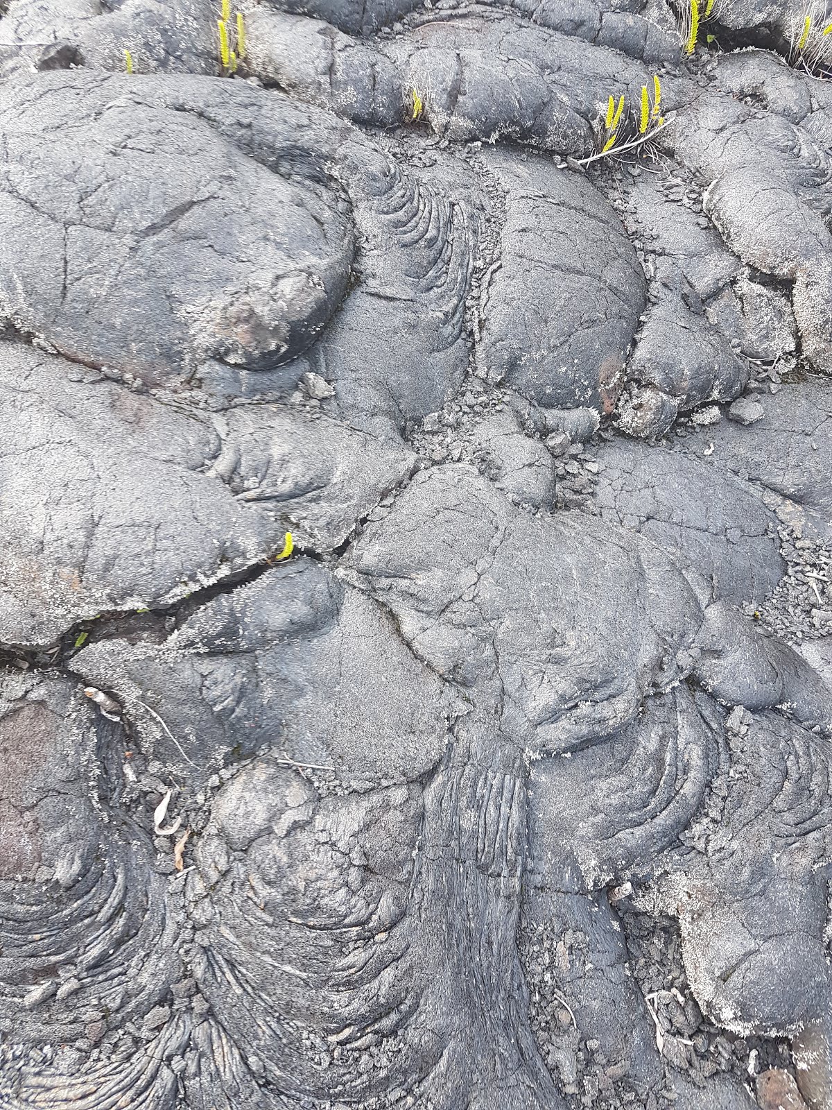
| The Fig.7: This photo-sample of the lava rock resembles a wrinkled skin of an elephant. Reunion, the South East stretch of the coast, taken with my smart phone, on January 2018. Obr.7: Tento foto-vzorek lávy připomíná svraštělou kůži slona. Reunion, JV úsek pobřeží, pořízeno mým chytrým mobilem, leden 2018. |
In fact the slope was an educative show of one of the volcano´s ability. The one which is able to melt ores in its inner furnace and to change them into a fluid material called the lava rock. In a following way the volcano releases the burning matter outside through its crater and it is streaming its slopes down destroying all what is standing in its way. At the same time as it is rolling down it is becoming colder and colder and its motion down the slope getting slower and slower. In the end it losses its fluid character and it returns to its original motionless stadium.
 |
| The Fig.8: Some fragments of the lava rock were covered with this lichen species. Reunion, the South East stretch of the coast, taken with my smart phone, on January 2018. Obr.8: Některé fragmenty lávy porůstal tento druh lišejníku. Reunion, JV úsek pobřeží, pořízeno mým chytrým mobilem, leden 2018. |
Well, several hours before I could see bizarre forms of the lava rock cliffs. I could examine their structure in a more detailed way. Now, in this part of the coastline, I could compare the previous wild stretches with the lava rock terrain rightly in front of my eyes. And I must say that they differed from each other in many various aspects.
 |
| The Fig.9: The same lichen as on the Fig.8 at the closer view. Reunion, the South East stretch of the coast, taken with my smart phone, on January 2018. Obr.9: Tentýž lišejník jako na obr.8 v bližším pohledu. Reunion, JV úsek pobřeží, pořízeno mým chytrým mobilem, leden 2018. |
On one hand the previous wild cliffs showed the more different appearance. They were crooked with a lot of crevices, holes, breaks and pits and they were in the tight contact with the ocean. They were dark brown or black in color, mostly they were wet ´cause inundated by the sea water permanently. They were bare, no vegetation grew on its furrowed surface.
On the other hand the lava rock covering the vast slope both above and under the road was at the longer distance from the ocean. Its surface was dry and much more lighter in color than the one of the wild lava rock cliffs. Perhaps the most interesting was its structure. How to describe it as apt as possible? After all to try it is useless if simply I can point out to my photos presented here. Despite the fact let me try to express the character with my own words.
Well, I would say that most of all the crooked lava rock surface resembled a lot of increments of some huge herd of the cattle to me. Separate smaller and bigger pieces of these pseudo cow shits overlapped each other at the direction of the slope´s fall down to the ocean. In places the eruptive rock looked like tufts of some mushrooms growing on three trunks or stubs. Often you could see various wrinkles and furrows forming manifold interesting or beautiful ornaments on surfaces of the eruptive rocks.
 |
| The Fig.10: A detailed photo of the furrows decorating the lava rock surface plus a starting colony of the lichen from the previous two pictures. Reunion, the South East stretch of the coast, taken with my smart phone, on January 2018. Obr.10: Detailní snímek rýh zdobících lávový povrch a počínající kolonie lišejníku z předchozích dvou obrázků. Reunion, JV úsek pobřeží, pořízeno mým chytrým mobilem, leden 2018. |
As for the vegetation composition of this remarkable habitat it was poor and stereotypical with variable densities from place to place. You could see the places where fast growing young trees or bushes covered the lava rock terrain already as well as the large fields of the bare lava rock where only a few of plant species were limited to crevices and breaks in the crooked terrain. I could recognize two dominant species of the ferns growing out of crevices among the lava rock fragments and also a few of tree seedlings plus a minimum of flowering plant species. In the mean time they have still been awakening to its exact botanic identifications. Some fragments of the lava rock were covered with some lichens, too.
 |
| The Fig.11: The first pioneering plants have been appearing in various crevices and breaks among lava rock fragments. Reunion, the South East stretch of the coast, taken with my smart phone, on January 2018. Obr.11: První pionýrské rostliny se objevují v rozmanitých štěrbinách mezi lávovými fragmenty. Reunion, JV úsek pobřeží, pořízeno mým chytrým mobilem, leden 2018. |
Personally I went further to the interesting terrain but not too far from the road above me. The crooked surface under my feet seemed to be fragile as if you were walking a thin crust threatening to collapse in every moment. But nothing similar happened to me.
We had an information that there was a lava rock cavern somewhere within the vast slope. Its inner room could be full of various fantastic lava artifacts, something like a lava rock analogy of a stalactite cavern. We tried to find it in the terrain under the road for a short time but in vain. Unfortunately, we had no exact GPS coordinates. The lava rock cave could be everywhere within the vast slope.
 |
| The Fig.12: You can see at least three different species of the ferns on this photo. Reunion, the South East stretch of the coast, taken with my smart phone, on January 2018. Obr.12: Na tomto snímku můžete vidět nejméně tři druhy odlišných druhů kapradin. Reunion, JV úsek pobřeží, pořízeno mým chytrým mobilem, leden 2018. |
Obviously this habitat has showed in a very educative way as the first pioneering plant species have been occupying the lava rock terrain gradually after last big eruption of the volcano named Piton de la Furnaise. I do not know exactly how much time flowed away from the last eruption but according to symptoms I could see I would estimate it at a time of seven or ten years.*
The place would have deserved to be explored much more thoroughly. We planned to visit to it once again but this purpose did not came to reality already. Maybe someday next.
The additional remarks:
* A time later I learnt that the volcano has been one of the most active ones in the world. They have said it has been active annually at various rates.
The Czech Version
Dvacet dní v ráji (VII)
 |
| The Fig.13: A photo taken from the lava rock terrain under the road. You can see the road and the lava terrain rising up above it. Reunion, the South East stretch of the coast, taken with my smart phone, on January 2018. Obr.13: Snímek pořízený z lávoviště pod silnicí. Můžete vidět silnici a lávový terén, který se zvedá nad ní. Reunion, JV úsek pobřeží, pořízeno mým chytrým mobilem, leden 2018. |
Ošemetný život mezi vulkánem
a Indickým oceánem
 |
| The Fig.14: The eruptive rock from the previous picture at the closest view. Reunion, the South East stretch of the coast, taken with my smart phone, on January 2018. Obr.14: Vyvřelina z předešlého obrázku v největším přiblížení. Reunion, JV úsek pobřeží, pořízeno mým chytrým mobilem, leden 2018. |
Žít mezi aktivní sopkou za zády a nesmírnými vodami Indického oceánu před sebou, inu, myslím, že tohle vždy nemůže být procházka růžovou zahradou. A Reunion opravdu do kategorie sopečných ostrovů patří. Jeho původ je vulkanický. Druhá nejvyšší hora ostrova zvaná Piton de la Furnaise (česky Vršek Pece) je pořád aktivní a čas od času umí předvést své ničivé schopnosti. Naštěstí, v době našeho pobytu na tomto krásném francouzském ostrově byla sopka absolutně klidná a tichá. To víte, chovala se jako vlk v rouše beránčím.
 |
| The Fig.15: This fern species belonged to the first pioneers occupying crevices of the bare lava rock fields. Reunion, the South East stretch of the coast, taken with my smart phone, on January 2018. Obr.15: Tento druh kapradiny patřil k prvním pionýrům osídlujícím štěrbiny holých lávovišť. Reunion, JV úsek pobřeží, pořízeno mým chytrým mobilem, leden 2018. |
Avšak v době mého vyprávění jsme se nacházeli daleko od jejího vrcholu skrytého za mraky a mlhou kdesi výše a hlouběji v hornatém vnitrozemí. Venda vlastně auto zastavil vedle silnice procházející nesmírným širokým svahem, který šplhal výš a výš nalevo nad silnicí a sestupoval až k oceánu na pravé straně ve směru naší jízdy z jihu na sever. Podíváte-li se na mapu ostrova, pak ten úsek můžete najít na jihovýchodním pobřeží.
 |
| The Fig.16: Here I succeeded in taking a picture of a flowering plant in the lava rock terrain. Reunion, the South East stretch of the coast, taken with my smart phone, on January 2018. Obr.16: Tady jsem uspěl v pořízení obrázku kvetoucí rostliny na lávovém terénu. Reunion, JV úsek pobřeží, pořízeno mým chytrým mobilem, leden 2018. |
Nebylo tam žádné lidské obydlí. Neviděli jste nic víc, než ten nesmírný svah a silnici v něm. Očividně se zdálo, že je ten silniční úsek nový, jeho asfaltový povrch byl hladký bez trhlinky či důlku a bílé čáry na něm byly bílé jako sníh.
 |
| The Fig.17: A young tree seedling growing out of crevice in the eruptive rock. The eruptive rocks here evoke, among many other comparisons, cakes of the cattle´s increments in my mind. Reunion, the South East stretch of the coast, taken with my smart phone, on January 2018. Obr.17: Semenáč mladého stromku vyrůstající ze štěrbiny ve vyvřelině. Tady mi vyvřeliny vyvolávají v mysli, mimo mnoho jiných příměrů, koláče dobytčích exkrementů. Reunion, JV úsek pobřeží, pořízeno mým chytrým mobilem, leden 2018. |
Nebyli jsme v té zvláštní holé krajině sami. Vedle silnice stálo několik jiných aut a jejich majitelé se potulovali po blízkém okolí stejně jako my. Výše ve svahu na protější straně silnice byla vyhlídka na Indický oceán. Někteří z návštěvníků ji použili, ale my se zdržovali poblíž auta. Zprvu jsme na místě seděli nebo postávali a rozhlíželi jsme se po tom odlehlém opuštěném terénu. Zejména pohled na nesmírné vody Indického oceánu byl fascinující. Jeho modrá hladina byla prázdná a klidná z jedné strany na druhou, od pobřeží až po obzor. Svah pod námi sestupoval k pobřeží postupně, a třebaže jsem ze svého místa nemohl vidět vlastní pobřeží, zdálo se, že k němu spadá nepřetržitě bez strmých útesů.
 |
| The Fig.18: The lava rock slope climbing up to the mountainous inland above the road. Reunion, the South East stretch of the coast, taken with my smart phone, on January 2018. Obr.18: Lávový svah stoupající do horského vnitrozemí nad silnicí. Reunion, JV úsek pobřeží, pořízeno mým chytrým mobilem, leden 2018. |
Zatímco jsem tam seděl, zapálil jsem si cigaretu a užíval si nesmírnost Indického oceánu i podivného svahu. Otevřený terén neposkytoval žádný stín. Slunce dělalo svou práci na modré obloze víc než dobře. Oceán sytil vzduch svými párami více než dostatečně. Byla to zkrátka vražedná kombinace horké pece a tropického skleníku. Vysoká relativní vlhkost vzduchu znesnadňovala dýchání, ale zvládali jsme tohle překonávat bez zdravotních problémů.
Ten svah byl vlastně názornou ukázkou jedné ze schopností sopky. Té, jež umí roztavit rudy ve své vnitřní peci a přeměnit je v tekutý materiál zvaný láva. Následně sopka uvolňuje žhnoucí hmotu ven kráterem a ta prýští svahy dolů a ničí vše, co jí stojí v cestě. Současně, jak se valí dolů, ochlazuje se a její pohyb dolů se zvolňuje. Nakonec ztrácí svůj tekutý charakter a vrací se k původnímu nehybnému stádiu.
Před několika hodinami jsem mohl vidět bizarní tvary lávových útesů. Mohl jsem si jejich strukturu prohlédnout podrobněji. Nyní, v této části pobřeží, mohl jsem porovnávat předešlé divoké úseky s lávovištěm přímo před očima. A musím říci, že se vzájemně lišily v mnoha aspektech.
 |
| The Fig.19: The fern with the wider and pointed leaves (behind the lava rock´s edge) and the fern with the slim erected leaves (to the left) grew together very often. Lower in the center of this picture you can see that Mimosa pudica was a next pioneering species in crevices of the lava rock slope. Reunion, the South East stretch of the coast, taken with my smart phone, on January 2018. Obr.19: Kapradina s širokými a zašpičatělými listy (za okrajem lávoviny) a kapradina se štíhlými vzpřímenými listy (nalevo) rostly společně velmi často. Níže uprostřed tohoto obrázku můžete vidět, že citlivka stydlivá (Mimosa pudica) byla dalším průkopnickým druhem ve štěrbinách lávového svahu. Reunion, JV úsek pobřeží, pořízeno mým chytrým mobilem, leden 2018. |
Na jedné straně předešlé divoké lávové útesy vykazovaly odlišnější vzhled. Byly křivolaké spoustou štěrbin, prohlubní, trhlin a jam a byly v těsném kontaktu s oceánem. Měly tmavohnědé nebo černé zbarvení, většinou byly mokré, protože permanentně zaplavované mořskou vodou. Byly holé, na jejich rozbráděném povrchu žádná vegetace nerostla.
Na druhé straně láva pokrývající nesmírný svah, jak nad silnicí tak i pod ní, byla od oceánu vzdálenější. Její povrch byl suchý a barevně mnohem světlejší, než povrch divokých lávových útesů. Snad nejzajímavější byla jeho struktura. Jak ji popsat co možná výstižně? Konec konců, zkoušet to je zbytečné, mohu-li poukázat na své fotky zde uvedené. Přesto mi dovolte, abych se pokusil vyjádřit ten charakter svými slovy.
Nu, řekl bych, že nejvíc ze všeho mi ten rozpukaný lávový povrch připomínal spoustu výkalů nějakého ohromného stáda dobytka. Jednotlivé větší nebo menší kusy těchto pseudo-kravinců se vzájemně překrývaly ve směru spádu svahu k moři. Místy se vyvřelina podobala trsům některých hub rostoucích na kmenech či pařezech stromů. Často jsem mohl vidět rozmanité vrásy či rýhy, které na povrchu vyvřelin vytvářely rozmanité zajímavé nebo krásné ornamenty.
 |
| The Fig.20: The photo shows the various density of the vegetation cover on the lava rock slope falling down to the Indian Ocean. Reunion, the South East stretch of the coast, taken with my smart phone, on January 2018. Obr.20: Foto ukazuje různou hustotu vegetačního krytu na lávovém svahu spadajícím k Indickému oceánu. Reunion, JV úsek pobřeží, pořízeno mým chytrým mobilem, leden 2018. |
Pokud jde o vegetační skladbu této pozoruhodné lokality, byla chudá a stereotypní při různých hustotách od místa k místu. Mohli jste pozorovat místa, kde už rychle rostoucí mladé stromy a keře lávoviště zakrývaly a také velká pole holé lávy, kde se jen nemnoho rostlinných druhů omezovalo na spáry a trhliny v rozpukaném terénu. Rozpoznal jsem dva dominantní druhy kapradin, které vyrůstaly ze štěrbin mezi fragmenty lávy a také pár semenáčků stromů a minimum kvetoucích rostlinných druhů. Prozatím stále čekají na přesné botanické určení. Některé úlomky lávy také porůstal nějaký druh lišejníku.
 |
| The Fig.21: A next view of the road and the upper part of the vast lava rock slope above the road. Reunion, the South East stretch of the coast, taken with my smart phone, on January 2018. Obr.21: Další pohled na silnici a horní část nesmírného lávového svahu nad silnicí. Reunion, JV úsek pobřeží, pořízeno mým chytrým mobilem, leden 2018. |
Osobně jsem do zajímavého terénu zašel dál, ale nepříliš daleko od silnice nade mnou. Zdálo se, že rozpraskaný terén pod mýma nohama je křehký, jako když kráčíte po tenké krustě, která hrozí, že se každou chvíli propadne. Avšak nic podobného se mi nepřihodilo.
Měli jsme informaci, že kdesi v tom nesmírně rozsáhlém svahu je lávová jeskyně. Její vnitřní prostor měl být plný fantastických lávových artefaktů, něco jako lávová analogie krápníkové jeskyně. Krátkou dobu jsme se ji pokoušeli najít v terénu pod silnicí, ale marně. Bohužel jsme neměli žádné přesné GPS souřadnice. Lávová jeskyně mohla být v tom rozsáhlém svahu kdekoliv.
 |
| The Fig.22: This scenery hypnotized me. Reunion, the South East stretch of the coast, taken with my smart phone, on January 2018. Obr.22: Tato scenérie mě hypnotizovala. Reunion, JV úsek pobřeží, pořízeno mým chytrým mobilem, leden 2018. |
Tahle lokalita očividně názorně ukazovala, jak lávový terén postupně osídlují první průkopnické druhy rostlin po poslední veliké erupci sopky Piton de la Furnaise. Nevím přesně, kolik času od poslední erupce uplynulo, ale podle příznaků, které jsem mohl vidět, bych to odhadoval na dobu sedmi či deseti let.*
 |
| The Fig.23: I was standing on a wrinkled eruptive rock and I was photographing young ferns growing out of a crevice. Reunion, the South East stretch of the coast, taken with my smart phone, on January 2018. Obr.23: Stál jsem na svraštělé vyvřelině a fotil mladé kapradiny vyrůstající ze štěrbimy. Reunion, JV úsek pobřeží, pořízeno mým chytrým mobilem, leden 2018. |
Místo by si bývalo zasloužilo prozkoumat důkladněji. Měli jsme v plánu navštívit ho ještě jednou, ale tento záměr se už neuskutečnil. Snad někdy příště.
Dodatečné poznámky:
* O nějakou dobu později jsem se dozvěděl, že sopka je jedním z nejaktivnějších vulkánů na světě. Prý je v různém stupni aktivní každoročně.
Žádné komentáře:
Okomentovat